Search Term Record
Metadata
Search Term |
Streets & Development |
Related Records
-
2-1020 - Christmas tree, Santa, seated congregation
Inside First Baptist Church, Coppell. Photo says, "Christmas party at 1st Baptist on Bethel." (P. Wilson, resident, 12/22/11) Santa is holding Caroline McCain. 1st row: Bob & Imogen Etheridge, Rita Parker. 2nd row: Sandra Pirkle. 3rd row: Travis Maynard.
Record Type: ALL PHOTOS
-
-
2-1171 - Building under construction; red & blue cars at right
The NW corner of Denton Tap Rd. and Bethel School Rd. The construction of a new medical building. This is the site of J.C. Thweatt's trailor park; before that, old houses. Photo taken in July, 2013. (P. Wilson, resident, 8/29/13)
Record Type: ALL PHOTOS
-
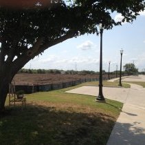
2-1174 - Street lamps, sidewalk, tree, bench, empty field
The east side of S.S. Coppell Rd., looking southeast. The field is being cleared to build 65 town homes, the 2nd phase of building residences in Old Downtown Coppell. Wilson house at 708 S S. Coppell Rd. is off to left. Photo made by Pete Wilson in August, 2013. (P. Wilson, resident, 8/29/13)
Record Type: ALL PHOTOS
-
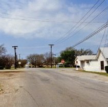
2-1182 - Road; Texaco sign on left; white buildings on right
W. Bethel Rd., showing the corner of W. Bethel & S. Coppell Rds., looking west. Photo made in 1983. (P. Wilson, resident, 10/25/13)
Record Type: ALL PHOTOS
-
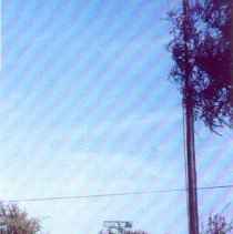
2-1185 - Road; telephone poles
According to Bob Freeman, who made this photo in 1985, this is Denton Tap Road. Bob Freeman,is a Coppell professional photographer and son of Jeanne Heath. (P. Wilson, resident, 10/25/13)
Record Type: ALL PHOTOS
-
2-1187 - "Coppell Town Center" sign on wooded street corner.
Intersection of Sandy Lake and Denton Tap Roads, looking SE. Photo made in 1987. (P. Wilson, resident, 10/25/13)
Record Type: ALL PHOTOS
-
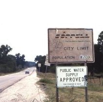
2-1202 - City limit sign; road; "Public water supply"
Coppell city limit sign in 1983. W. Bethel Road, most likely looking west, near the top of the hill; present location of Cici's Pizza offices. (P. Wilson, resident, 10/25/13)
Record Type: ALL PHOTOS

-
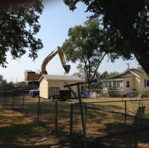
2-1216 - Power shovel on mound of dirt; yellow house; chain-link fence
The property along S.S. Coppell Road being prepared for 65 new homes as part of the Main Street project. The Wilson house at 708 S. Coppell Rd. in front. Looking SW. Photo made in 2013. (P. Wilson, resident, 10/25/13)
Record Type: ALL PHOTOS
-
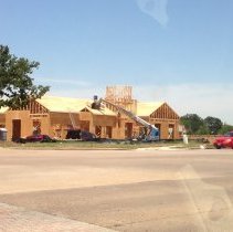
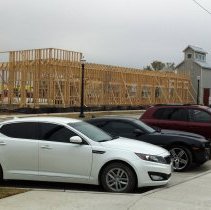
2-1218 - New wood frame of building; 3 vehicles parked in front
The Local Diner being built as part of the Main Street project in Old Coppell. S. side of W. Bethel Rd. Photo taken in 2013. (P. Wilson, resident, 10/25/13)
Record Type: ALL PHOTOS
-
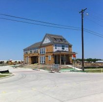
2-1219 - House being constructed; telephone pole to right
The first home built on the west side of S.S. Coppell Rd. as part of the Main Street project. Photo made in 2013. (P. Wilson, resident, 10/25/13)
Record Type: ALL PHOTOS
-
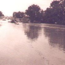
2-134 - Flood; bridge; cars
See comments on photo #128 - some vehicles. Note that cars look fairly modern. (Pete Wilson, resident, 12/14/01) I don't know what year, but I do remember seeing this maybe Spring 1963. (Barbara Lee, 10/20/02)
Record Type: ALL PHOTOS
-
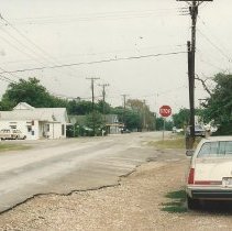
2-1403 - Car on right; telephone poles; stop sign; downtown
Old downtown Coppell, 1988. Road in foreground is W. Bethel Rd. Cross street is S. Coppell Rd., facing east. Barbershop on corner; Harwell house next to it. Store in center is NAPA Auto Parts, but site was originally early general stores. Car in foreground is mine, a Lincoln Mark VII sitting in front of original Baptist Church. (P Wilson, resident, 11/7/14)
Record Type: ALL PHOTOS
-
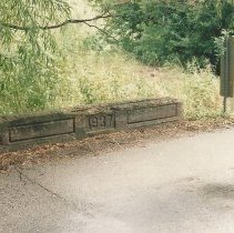
2-1405 - Small bridge, "1937"
Small bridge over Bethel Rd. between Coppell Road and Loch Lane, over the creek. Looking south. 1988. (P. Wilson, resident, 11/7/14)
Record Type: ALL PHOTOS
-
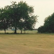
2-1406 - Grove of trees, field
Site of first and second school buildings in Coppell. Near corner of W. Bethel and Coppell Rd., just west of site of First Baptist Church. Also site of Arnett house, just south of site of Locket Woods house. Looking west. 1988. (P. Wilson, resident, 11/7/14)
Record Type: ALL PHOTOS
-
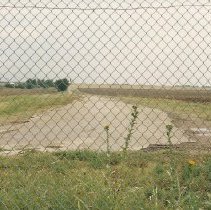
2-1408 - Old road behind chain-length fence
The old path of Coppell Rd. from Coppell to Grapevine, taken from present W. Bethel Rd, looking south. The fence is property of DFW Airport. Terry Kirkland's house was on left after first tree. This road eventually crossed Cotton Belt Railroad and followed the railroad west to Grapevine before Highway 121. Location of site, one mile due west of downtown. 1988. (P. Wilson, resident, 11/7/14)
Record Type: ALL PHOTOS
-
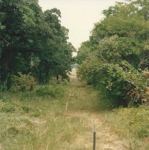
2-1409 - Trail through trees; fence in foreground
The path of old Hertz Rd. Taken from Sandy Lake Rd., looking north. 1988. (P. Wilson, resident, 11/7/14)
Record Type: ALL PHOTOS
-
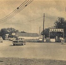
2-1450 - Coppell/Bethel street sign. "Conoco."
Downtown Coppell, looking east, 1972. Note: Photos #1450, 1451, & 1452 appeared in The Dallas Times Herald, June 10, 1972. (P. Wilson, resident, 3/12/18)
Record Type: ALL PHOTOS
-
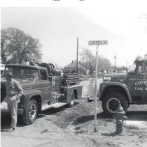
2-1472 - 2 firetrucks; fire plug; street sign
Two of Coppell's firetrucks from the 1960s. On southeast corner of W. Bethel & S. Coppelll Rds., looking northeast. Note street sign. Fireplug was the first in town, according to Richard Lee, former Fire Chief. Old Standifer house in background. August, 1966. (P. Wilson, resident, 8/6/19)
Record Type: ALL PHOTOS
-
2-341 - Stop sign, street sign, pole
Stop sign along Denton Tap Road. (Probably at Sandy Lake Road.) (P. Wilson, resident, 9/13/06)
Record Type: ALL PHOTOS